Datasheets
![]() DR680 Datasheet (PDF – 154KB)
DR680 Datasheet (PDF – 154KB)
![]() DR1560 Datasheet (PDF – 309KB)
DR1560 Datasheet (PDF – 309KB)
![]() LMS-Q780 Brochure (PDF – 1.32MB)
LMS-Q780 Brochure (PDF – 1.32MB)
![]() LMS-Q780 Datasheet (PDF – 1.04MB)
LMS-Q780 Datasheet (PDF – 1.04MB)
![]() RiACQUIRE Datasheet (PDF – 686KB)
RiACQUIRE Datasheet (PDF – 686KB)
![]() RiANALYZE Datasheet (PDF – 555KB)
RiANALYZE Datasheet (PDF – 555KB)
![]() RiMTA ALS Datasheet (PDF – 336KB)
RiMTA ALS Datasheet (PDF – 336KB)
![]() RiPROCESS Datasheet (PDF – 901KB)
RiPROCESS Datasheet (PDF – 901KB)
![]() RiWORLD Datasheet (PDF – 374KB)
RiWORLD Datasheet (PDF – 374KB)
![]() VQ-1560i Datasheet (PDF – 1.32MB)
VQ-1560i Datasheet (PDF – 1.32MB)
![]() VQ-1560i Infosheet (PDF – 2.05MB)
VQ-1560i Infosheet (PDF – 2.05MB)

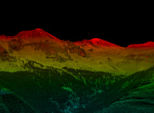
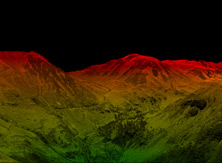
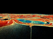
Using RIEGL LiDAR scanners, wide area mapping can be done in a minimal amount of time with maximum accuracy and precision of the acquired data. The proven waveform LiDAR provided by the airborne scanners have been extensively tested and proven in multiple wide area mapping missions across the world.
The NEW RIEGL VQ-1560i is an ultra-high performance, fully integrated and calibrated dual channel airborne mapping system that is perfectly suited for the challenging demands of the most complex airborne mapping missions. The system’s capability of both online waveform processing, as well as full or smart waveform, recording, results in unsurpassed information content collected on each single target.
Over 1.3 million measurements are collected on the ground per second at altitudes of up to 15,5000 feet, allowing operation at various flight altitudes and a wide range of point densities with faster and more efficient flight planning and safer flights possible. This makes the system well suited for aerial survey of ultra-wide areas, as well as complex environments.
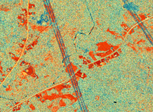
A versatile, high altitude airborne LiDAR sensor, the RIEGL LMS-Q780 delivers high efficiency at low operating costs. Effective spacing on the ground from multiple simultaneous pulses in the air eliminates the need of terrain following while still retaining a high effective rate.
Straight parallel scan lines and equally spaced laser footprints on the ground can detect even small objects with the matrix scan pattern. The 60-degree field of view provides a wide effective swath width and narrow point space, minimizing operating costs.
For the full line of airborne scanners able to be utilized for wide area mapping, please visit our Airborne Scanners page here.
Gallery