Datasheets
ALS
![]() LMS-Q780 Datasheet (PDF – 1.04MB)
LMS-Q780 Datasheet (PDF – 1.04MB)
![]() LMS-Q780 Infosheet (PDF – 1.32MB)
LMS-Q780 Infosheet (PDF – 1.32MB)
![]() LMS-Q1560 Datasheet (PDF – 1.36MB)
LMS-Q1560 Datasheet (PDF – 1.36MB)
![]() LMS-Q1560 Infosheet (PDF – 1.88MB)
LMS-Q1560 Infosheet (PDF – 1.88MB)
![]() RiACQUIRE Datasheet (PDF – 487KB)
RiACQUIRE Datasheet (PDF – 487KB)
![]() RiANALYZE Datasheet (PDF – 555KB)
RiANALYZE Datasheet (PDF – 555KB)
![]() RiMTA ALS Datasheet (PDF – 336KB)
RiMTA ALS Datasheet (PDF – 336KB)
![]() RiPROCESS Datasheet (PDF – 520KB)
RiPROCESS Datasheet (PDF – 520KB)
![]() RiWORLD Datasheet (PDF – 374KB)
RiWORLD Datasheet (PDF – 374KB)
![]() VQ-480i Datasheet (PDF – 463KB)
VQ-480i Datasheet (PDF – 463KB)
![]() VQ-580 Datasheet (PDF – 1.08MB)
VQ-580 Datasheet (PDF – 1.08MB)
![]() VUX-1LR Datasheet (PDF – 652KB)
VUX-1LR Datasheet (PDF – 652KB)
TLS
![]() RiDB Datasheet (PDF – 408KB)
RiDB Datasheet (PDF – 408KB)
![]() RiMONITOR Datasheet (PDF – 426KB)
RiMONITOR Datasheet (PDF – 426KB)
![]() RiMTA TLS Datasheet (PDF – 1.04MB)
RiMTA TLS Datasheet (PDF – 1.04MB)
![]() RiSCANPRO Datasheet (PDF – 524KB)
RiSCANPRO Datasheet (PDF – 524KB)
![]() RiSOLVE Brochure (PDF – 1.73MB)
RiSOLVE Brochure (PDF – 1.73MB)
![]() RiVLib Datasheet (PDF – 117KB)
RiVLib Datasheet (PDF – 117KB)
![]() VZ-400i Datasheet (PDF – 2.58MB)
VZ-400i Datasheet (PDF – 2.58MB)
![]() VZ-400i Infosheet (PDF – 1.70MB)
VZ-400i Infosheet (PDF – 1.70MB)
ALS
![]() RiACQUIRE Datasheet (PDF – 487KB)
RiACQUIRE Datasheet (PDF – 487KB)
![]() RiCOPTER Infosheet (PDF – 704KB)
RiCOPTER Infosheet (PDF – 704KB)
![]() RiCOPTER with VUX-SYS Datasheet (PDF – 1.20MB)
RiCOPTER with VUX-SYS Datasheet (PDF – 1.20MB)
![]() RiMTA ALS Datasheet (PDF – 336KB)
RiMTA ALS Datasheet (PDF – 336KB)
![]() RiPROCESS Datasheet (PDF – 520KB)
RiPROCESS Datasheet (PDF – 520KB)
![]() RiWORLD Datasheet (PDF – 501KB)
RiWORLD Datasheet (PDF – 501KB)
![]() VUX-1 Series Infosheet (PDF – 3.67KB)
VUX-1 Series Infosheet (PDF – 3.67KB)
![]() VUX-1UAV and VUX-SYS Forestry and Agriculture Infosheet (PDF – 1.28MB)
VUX-1UAV and VUX-SYS Forestry and Agriculture Infosheet (PDF – 1.28MB)
![]() VUX-1UAV Datasheet (PDF – 647KB)
VUX-1UAV Datasheet (PDF – 647KB)
![]() VUX-SYS Datasheet (PDF – 573KB)
VUX-SYS Datasheet (PDF – 573KB)

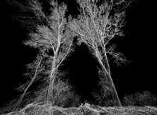
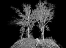
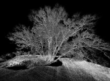
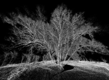
Forestry, as an industry, is critical to countries all over the world as an important renewable resource. As such, forests need to be carefully monitored and maintained to ensure that their sustainability, overall health, and economic benefits continue to flourish.
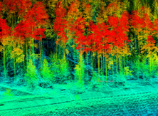
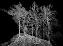
Utilizing unmanned, airborne, or terrestrial RIEGL LiDAR systems, resulting in the creation of high density point clouds, is ideal for a variety of forestry applications such as continuous crop monitoring during growth periods, observation of irregularities in plant growth, detection of hail damage, analysis of terrain changes, analysis of variation in forest growth and performance, yield estimation, observation of nutrient over- or undersupply, identification of high-value wood products, reduction of negative environmental impacts, prediction of accurate forest metrics, and long term regular observation of growth characteristics for geological evaluation and classification, amongst others.
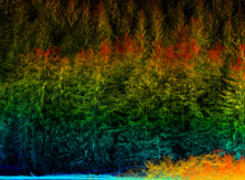
Excellent vegetation penetration rate from RIEGL LIDAR scanners result in a high number of ground returns that can be used to generate detailed terrain models.
All points classified as vegetation can be colored by relative height above ground. This yields for a relative estimation model of the trees revealing regions of low and high vegetation stands. Growth rates can be documented by comparison of height models collected over a period of time.
The technique of laser scanning enables the user to capture data suitable for the generation of Digital Surface Models (DSM) and Digital Terrain Models (DTM).
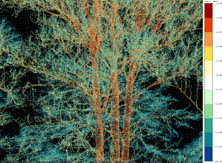
Advanced processing algorithms account for a full exploitation of the information included in the scan data. A typical target situation is measuring areas covered by vegetation. Several target echoes resulting from a single laser pulse emission are obtained by echo digitization and subsequently resolved by online waveform processing, resulting in measurement ranges, echo amplitudes, calibrated target reflectance, and pulse shape information.
Crop growth and health are closely monitored in precision farming in order to minimize the use of fertilizers or irrigation. Airborne laser scanning data enables the user to observe plant growth- while at the same time displaying changes in ground surface- or to detect areas of irregularities.
While plant height cannot, per se, be interpreted as a direct factor for yield calculation, irregularities due to different soil composure, variety of seed type or damage (e.g., weather-related caused by storm, hail, or rainfall) can easily be discerned and taken as an indicator for further developments and estimation of yield at harvest.
Constant monitoring of agricultural areas enables early yield estimation based upon differences in plant growth development.
Article
https://rieglusa.wordpress.com/2016/09/20/customer-spotlight-leading-edge-geomatics/
Please note that “references to any specific commercial products, processes or services or the use of any trade, firm or corporation name are for the information and convenience of the reader and do not constitute endorsement, recommendation or favoring by the US government or National Aeronautics and Space Administration”.
“Shining a G-LiHT on an Alaskan Forest”
http://earthobservatory.nasa.gov/IOTD/view.php?id=88450&eocn=home&eoci=iotd_title
“Taking the Measure of a Remote Slice of Alaskan Forest”
https://blogs.nasa.gov/earthexpeditions/2016/07/20/taking-the-measure-of-remote-slice-of-alaskan-forest/
“NASA Goddard Technology Helps Fight Forest Pests”
http://phys.org/news/2015-07-nasa-goddard-technology-forest-pests.html
“How a Flying Laser Built a 3-D Map of a Massive Alaskan Forest”
https://www.wired.com/2014/12/alaska-laser-survey-3d-map/
“NASA-USFS Survey of Interior Alaska Forests”
https://instagram.com/p/su0JPkN_LB/
“A Closer Look at Alaska’s Forests”
http://earthobservatory.nasa.gov/IOTD/view.php?id=84068
“G-LiHT: Connecting the Dots”
http://earthobservatory.nasa.gov/blogs/fromthefield/2014/07/22/g-liht-connecting-the-dots/
“NASA in Alaska 2014: A Frozen Fieldtrip from Fairbanks”
http://earthobservatory.nasa.gov/blogs/fromthefield/2014/07/21/a-frozen-fieldtrip-from-fairbanks/
“G-LiHT: A View From Above”
http://earthobservatory.nasa.gov/blogs/fromthefield/2014/07/21/a-view-from-above/
“G-LiHT: Off to a Flying Start”
http://earthobservatory.nasa.gov/blogs/fromthefield/2014/07/17/g-liht-campaign-off-to-a-flying-start/
Gallery